Facilities
UMBC
UMBC/CUERE
houses a Spatial Analysis Laboratory in the Technology Research Center
(TRC) that is a joint
venture
with
the
Baltimore
Ecosystem
Study, Institute for Ecosystem Studies, and USDA Forest Service.
The mission of the laboratory is to apply an
interdisciplinary approach to advance the understanding of human
impacts on the environment through the provision of spatial analysis
and data visualization.
The lab is equipped with a robust database and file server, seven GIS
work stations,
a large format plotter, a large format scanner, GIS and Spatial
Analysis Software
and data sets for staff, faculty, and student research. CUERE recently
upgraded
the laboratory with 5 new Dell 690 Precision Workstations. These
workstations
consist of two 2.6 GHZ Intell Dual Core processors, 4GB of RAM, 500GB
of hard
drive storage,
and dual high resolution flat panel
displays.
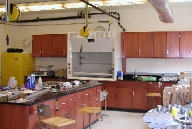
CUERE also houses an environmental research laboratory to provide
dedicated space for intern/extern and graduate student research, a
field lab for visiting scientists, a field and laboratory
methodology classroom, an experimental and analytical demonstration
space; and a soil sample processing area. The lab provides
for: soil physical and chemical properties analysis,
soil sample processing for external analysis, and water chemistry and
quality analysis
The lab is equipped with a ventilation fume hood, drying ovens,
furnaces and sink space with large sample processing areas and
integrated utilities. It
includes storage spaces for equipment, glassware, and lab materials.
There
is also dedicated bench space and whiteboard for lecture, demonstration
and practice. The
lab is handicap accessible and has a mudroom for field equipment and
clothing.
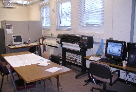
Under
support of NSF and NOAA, a data analysis and visualization laboratory
was completed in the Technology Research Center in December 2008 (see photograph below).
Included in the hardware for this laboratory are 1 Dell PowerEdge 2950
server connected to a Dell PowerVault MD1000 SATA disk array with 6.5
terabytes of fully mirrored storage, 12 Dell T7400 workstations – each
with dual 22 inch widescreen monitors, one HP DesignJet T1000 MFP large
format plotter/scanner, and an array of 8 Viewsonic CD4620 46-inch
monitors covering approximately 64 square feet and containing
approximately 16.6 million pixels.
CUERE owns a SET 510 Total Station, several weather stations, and a
Sontek Flowtracker
acoustic Doppler velocimeter and a Gurley Pygmy Current Meter (Model
625). We
have access to survey-grade GPS equipment through a pending agreement
with MD
Dept. of the Environment.
The Department of Civil and Environmental Engineering, also located in
the TRC,
has over 2250 ft^2 of lab space. Labs are equipped with fume hoods,
analytical
grade water, and chemical resistant countertops. One laboratory has
been dedicated
to analytical instruments and one room for sample preparation. Basic
laboratory
equipment includes analytical balances, meters (pH, specific ion probe,
DO, conductivity,
turbidity, COD), shaking tables, centrifuge, refrigerators, vacuum
pumps, drying
ovens, UV-VIS spectrophotometer, microscopes, and titrators. Civil and
Environmental
Engineering has recently completed purchases of major equipment for its
labs.
The equipment (GC-MS, ICP-MS, IC-MS, spectrophotometer) allows for
analysis of
a wide range of organic and inorganic constituents in water and soils.
UMBC’s Department of Mathematics and Statistics has available for
parallel
processing a 64-processor Beowolf cluster “kali”, funded originally
by a National Science Foundation SCREMS grant (DMS-0215373). The
cluster has
32 dual-processor nodes with Intel Xeon 2.0 GHz CPUs and at least 1 GB
of memory
per node. A central RAID array with 0.5 TB disk space is available. The
nodes
are connected by a high-performance Myrinet interconnect with low
latency. More
detailed information about kali is available at http://www.math.umbc.edu/~gobbert/kali.
The tight coupling via the Myrinet interconnect makes the cluster
suitable for
closely-coupled parallel code involving frequent rapid
processor-to-processor
communication. At the same time, the number of CPUs available on “kali”
allow
for efficient extensive parameter studies of serial (or small-scale
parallel)
code. The cluster is actively being used for both types of parallel
applications.
UMBC is seeking funds in 2007 via the MRI competition to upgrade and
expand this
cluster.
UMBC has a state-of-art campus network providing Gigabit network access
to all
major buildings and research labs and switched ethernet connections to
every
room. All residential facilities have a dedicated 10 MB connection for
each resident
student. UMBC provides approximately 500 modems serving the Baltimore/
Washington
region. All members of the community have access to high-speed Internet
connectivity,
a 155MB connection for Internet1 and 155 MB connection for Internet2.
Currently,
wireless network access is available throughout much of the campus,
including
the entire New Commons building, which has up to 25 wireless laptops
for free,
two-hour loans inside the building. In Spring 2004, UMBC was noted as
one of
the top 25 "wireless" schools by Intel.
Baltimore
Ecosystem Study (BES) LTER Field Site
The
main focus area of the test-bed study is the Gwynns Falls watershed, a
171-sq km basin that lies within the Patapsco drainage to the
Chesapeake Bay. The watershed was selected in 1997 as part of an urban
LTER study site because it is characterized by a gradient of
urbanization stretching from downtown Baltimore to the surrounding
suburbs, with a few small remnant agricultural areas at the headwaters.
Baisman Run, a forested subwatershed in the Gunpowder drainage, serves
as a control. The field headquarters of the BES and affiliated USDA
Forest Service personnel are housed in the Technology Research Center
(TRC) at UMBC, hosted by the Center for Urban Environmental Research
and Education (CUERE, http://www.umbc.edu/cuere,
C. Welty, Director). UMBC is situated just outside the watershed
boundary in Catonsville, MD.
Eleven USGS stream gauges are actively collecting data in the BES study
area by USGS in a nested watershed design to span different types of
land use and land cover. A network of meteorological stations also is
in place. Hydrography, soils, and geology are available for the area in
digital form. In addition, a number of spatial-data products from
airborne surveys are available that capture landscape physical features
at a very fine scale. We have previously purchased LIDAR (Light Image
Detection and Ranging) data of the landscape from 2002 that quantify
the urban/suburban topography on a 1-m horizontal and 10-cm vertical
resolution. Baltimore and Howard Counties have recently acquired new
sets of LiDAR data flown in 2005/06 that are available for project use,
and Carroll County will take delivery of new LiDAR data in the first
quarter of 2007. EMERGE® airborne color-infrared imagery is available
that provides a high-resolution aerial photography record. We also have
available to us 1-ft resolution orthoimagery for the years 1996, 2000,
2002, 2004, and 2005 from Baltimore County; and from Baltimore City we
have 3-in. resolution orthoimagery from 2000 and 1-ft. resolution
orthoimagery from 2004. Multi-spectral (4-m resolution) and
panchromatic (1-m resolution) IKONOS imagery for Baltimore captured in
2000 is also available.
Rainfall fields covering the entire Gwynns Falls watershed at a 1 km^2
grid scale can be constructed based on NEXRAD weather radar products
using the local rain gage network for bias correction. Analyses are
based on official National Weather Service rain gages supplemented by
rain gage networks maintained by Baltimore City, Baltimore County and
BES with radar reflectivity observations from the Sterling, Virginia
WSR-88D radar.
USGS
MD-DE-DC Water Science Center
In August 2007 the MD-DE-DC Water Science Center moved to
UMBC’s
campus under a long-term cooperative agreement. The university has
constructed
a 23,500 sq ft building for USGS. Included in this facility are a
wet lab,
GIS facilities, an equipment warehouse, and a fleet of 36 field
vehicles outfitted
for hydrologic monitoring and measurement. 60+ personnel are housed
in this
building as a nearby technical resource in hydrologic measurement and
analysis.
Cary Institute
of Ecosystem Studies, NY
The 3,066 square meter (33,000 square feet)
Plant Science Building and the 1,254 square meter (13,500 square foot)
Gene E. Likens Laboratory house state-of-the-art laboratories for
organic and inorganic analyses. A 10,500-volume scientific reference
library in the Plant Science Building receives 175 journals and
accesses the DIALOG and Current Contents databases; three computer
workstations are available for use by library patrons. General computer
facilities, a herbarium, and a well-equipped darkroom are located in
this building as well, along with administrative offices, a classroom,
conference room, and meeting area that provides space for small
workshops and conferences. Adjacent to the Plant Science Building is a
150-seat auditorium and teleconferencing center. Other buildings house
1,370 square meters of greenhouse space, cold storage facilities, a
lath house and storage buildings, carpentry and mechanical shops.
Dormitory facilities are available to house students while in
residence. Three renovated farmhouses can accommodate visiting
scientists and their families on extended stays.
Analytical facilities at the Institute are state of ¬the art and make
possible a wide variety of new as well as ongoing research programs.
The IES Analytical Laboratory is serviced by a Laboratory Information
Management System (LIMS). Instrumentation includes a Waters HPLC system
with controller, photodiode array detector, autosample and Millennium
chromatography analysis software; three Shimadzu model GC 8, one Tracor
gas chromatograph with thermal conductivity, flame ionization and
electron capture detectors; Perkin Elmer Analyst 300 atomic absorption
spectrometer with graphite furnace; Perkin Elmer P400 inductively
coupled plasma emission spectrometer, and autosampler; Carlo Erba NA
1500 CNS analyzer; three Dionex DX500 ion chromatographs; two high
quality Shimadzu UV visible dual beam spectrophotometers; Perkin-Elmer
spectrofluorometer and plate reader; Alpkem Flow Solution III Analyzer;
Perstorp Analytical EnviroFlow 3000 Analyzer; two Turner Designs
fluorometers; micro Kjeldahl analyzer, Shimadzu model 5050C gas
analyzer for determination of dissolved and particulate carbon; leaf
area meter; optical microscopes; inverted microscope; fluorescence
microscopes; glove box; two image analyzers; Rockman L5C-1600
scintillation counter; ultra centrifuge; laminar flowhood; freeze
dryer; drying ovens; rotary evaporators; incubators; walk in cold room;
Ultra low freezer; muffle furnace; soil processing equipment;
electronic balances (including microbalances); pH meters and electrical
conductivity meters.
University of North Carolina
The
Department of Geography at UNC has a fully equipped GIS and
Environmental Modeling Laboratory, including a combination of high end
Sun and PC platforms, in excess of 200GB disk storage, tape robots,
digitizing tablets, and large scale plotters, as well as access to a
UNC Beowulf Cluster, and the North Carolina Supercomputing Center.
The Geomorphology and Sample Processing Laboratory at UNC includes
equipment needed for:
• geomorphic surveys (Trimble 3500 Total Station, TopCon AT-6 Auto
Levels(3))
• hydraulic measurements (Marsh-McBirney velocity-meter, SonTek 2-D
acoustic velocity-meter)
• sediment size analysis (coarse sediment sieves, Ro-Tap shaker,
hydrometers, drying ovens, analytical balances)
• fluvial sediment collection (USBLH-84 bedload sediment samplers,
DH-48
suspended sediment samplers)
• water samplers (ISCO automated 24-sample collector)
• conservative and solute tracer injections (GeoPump peristaltic pump,
FMI Metered peristaltic pump, YSI-55 conductivity meter, Aquafluor
field flourometer)
• Dynamax theta probes and TRASE TDR for soil moisture measurements
• Soil Moisture tensiometers